Orciatico develop itself in Valdera and it’s brush against with the torrent Fosce at North whereas it is brush against the torrent Foscecchia in the south.
In the vicinity of the hamlet, some scientists did investigations on the natural events of the emission of carbon dioxide, they were just documented by Giovanni Targioni Tozzetti in XVIII century.
HISTORY
The hamlet born under the dominion of Lajatico, it remained under the dominion of it since the XII century, when both of the castles were assigned to the bishop Ildebrando Pannocchieschi of Volterra. In 1434 the stronghold of Orciatico was dismantled by the citizens of Florence.
La Sterza is an hamlet in the middle of the community of Lajatico and Terricciola.
HISTORY
The history of the territory of La Sterza is linked to the unknown district of Pava. It mentioned in two documents edit the 1st August 1109 and 21st June 1112 at Volterra. The hamlet in the early medieval passed to Pannocchieschi in 1186.
Here it was situated the church of San Giovanni, it counted five churches under his jurisdiction. The church will be well-known as Pitti’s church by the name of Florentine family, they were owner of the estate. What remains of this hamlet is an ancient farmhouse, today it is the headquarter of a farm and agritourism, whereas the modern hamlet has evolved at the slope in the beginning of XIX century. La Sterza shows up as a modern agricultural hamlet, where there are mainly farm artisan job of the community of Lajatico.
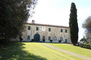
The Villa of Spedaletto (Lajatico) was one of the Ville of Lorenzo the Magnificent, he made it rebuild and he often stayed there. Although it was ceded after his death, it is one of the Medici’s villa.
Spedaletto is named for “spedale” of hospitalier knight of Altopascio situated in the surroundings of Via Francigena. This “spedale dei Santi ippolito e Cassiano” was granted to Lorenzo the Magnificent in 1486.
The zone was strategic for i Medici, because Volterra was conquered for his precious cave in 1472. In the vicinity of it there are hot springs of Bagno a Morba, the mother of Lorenzo has rented them. The family’s main branch of Medici suffered illnesses to the gout. Numerous were the sojourns of Lorenzo since one year before his die in 1492.
The farm of Spedaletto included twenty estate and it was reorganized by Lorenzo. The transformation to “casa da signore” of the main building was done between the 1487 and 1491.
HISTORY
The project seems it is connected to Simone del Pollaiolo dubbed “Cronaca”, he stayed at Spedaletto in 1490. But the villa had a easy structure, the magnificent was given by the plan of pictorial decorations with the Florentine painters who they were employed to the realizations of frescos, but today these frescos are lost. The mayor loggia and the salon, according to Giorgio Vasari, Filippino Lippi, Pietro Perugino e Sandro Botticelli had worked on it. The unique description more detailed reached to us was the pictorial cycle of Ghirlandaio.
After the death of Lorenzo in 1492 the villa was sold by his son “Piero il Fatuo” to Franceschetto Cybo in 1494. Then it followed the fates of the family since 1606, when Alberico I Cybo-Malaspina sold it to senator Bartolomeo Corsini. The Corsini are the actual owner of villa, their emblem stand out on the facade of building.
Unfortunately in XVII century the frescos were damaged by blaze. Today we have only scarce traces of them.
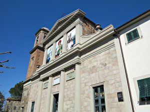
Dedicated to the holy Occitan San Leonardo of Noblac (whose worship is also practiced in the nearby village of Lari), its origins dates back to the 13th century, but the church was rebuilt in the nineteenth century when, on the design of the architect Angiolo della Valle , Important restorations were made to imprint neoclassical forms; The work was carried out between 1853 and 1856. The facade dates back to 1925 and is flanked by a bell tower built at the end of the nineteenth century. During World War II the building was damaged; The major altar, destroyed, was replaced in 1957.
The interior has three naves, with the central one covered by a barrel vault.
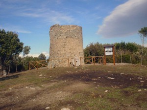
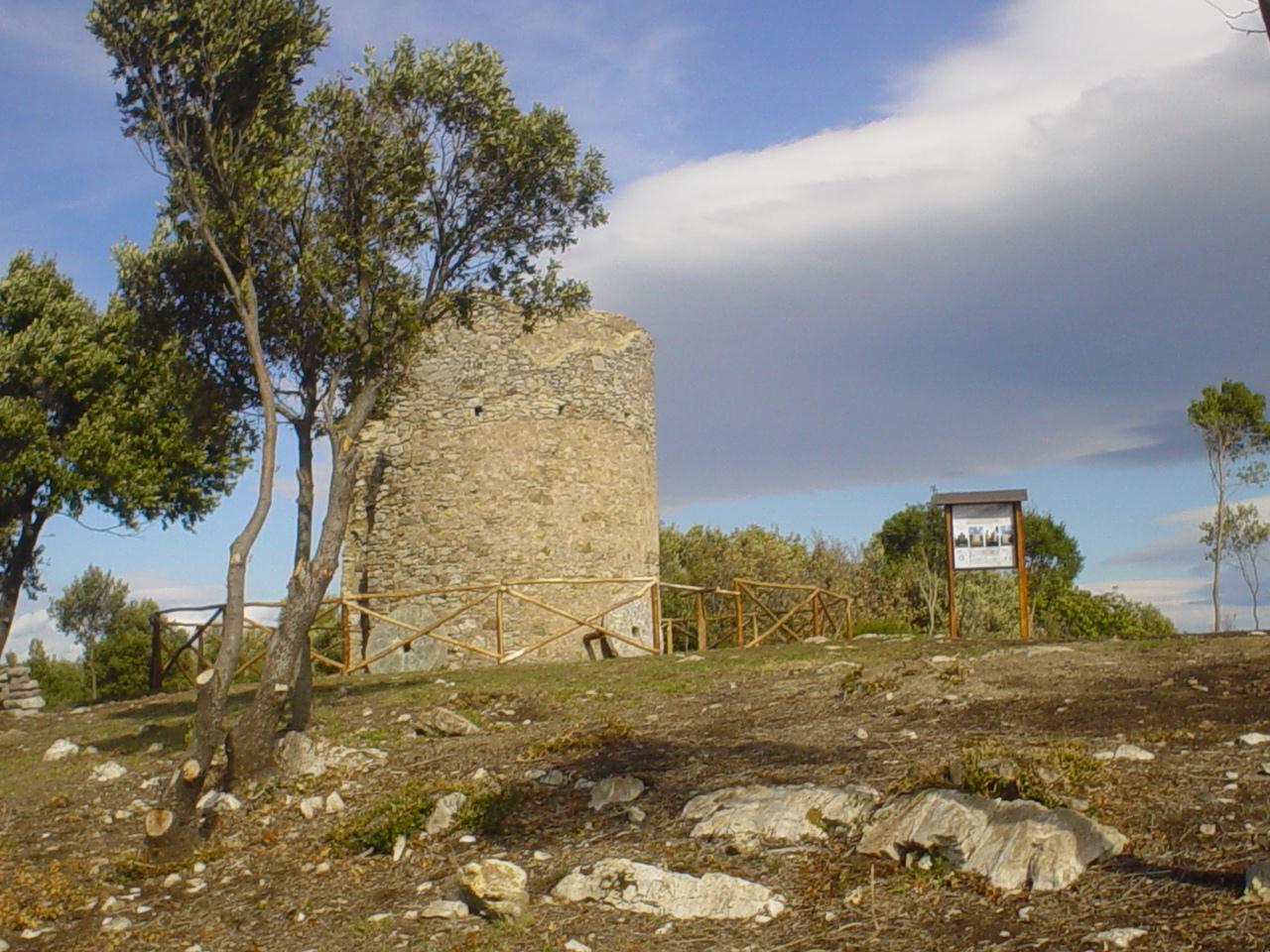
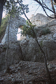
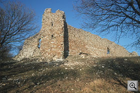
The Fort of Pietracassia can be considerate one of the most important high medieval monuments in the province of Pisa. The big limestone, at 550 meters above sea level, controls the street that connects Valdera with Valdicecina.
From an open fissure comes the name ‘Pietracassia’.
Monument history:
In 1115, the fort was purchased by Ugo Pannocchieschi, and in 1202 the territory and the fort was conquered by the Pisans.
It remained under Pisan control until 1286, when it was given back to Volterra.
In 1405, the traitor Pietro Gaetani gave the Pietracassia Fort and other castles in the Valdera to the Florentines.
At that time, there was a chapel dedicated to San Bartolomeo in the castle.
In 1434, Florence destroyed the castles of Pietracassia, Orciatico and Lajatico following a series of revolts by the local peoples.
From that moment onward, the Fort would be known solely as a part of the Spedaletto Property.
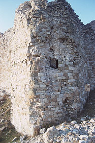
How it’s made:
The fort features a fortified wall with towers at all four corners. The wall extends along the southern side of the fortification complex, and the north side is protected by a cliff, making it impossible to impenetrate from the north.
The plan of the fort is square, and at each angle there are watchtowers. There is only one entranceway. Inside the fort, there are rooms where the troops slept and ate.
The fort surveilled the territory from the Pianura Pisana and the Verruca at the north to the Sillana Fort at the south The Pietracassia Fort is one of the best examples of military architecture in the area from the late Middle Ages. It dates back to the 17th or the 18th-century, and is one of the first barbaric castles in Tuscany.
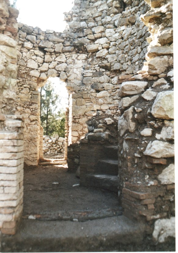
In the south of Orciatico there are two ruins of windmills. The first windmill is dating back to the second half of 17th century, It was recovered and It was restored. You can also admire the fantastic view and you can take some amazing photograph.
The second Windmill was built in the 18th century by Tommaso Tani, Project of total recovery is in study phase. The Windmills are in stone and they have two floor and a revolving turret in wood.
Route of Windmills in Orciatico
Type of route: environmental, naturalistic, historical
Lenght: 0,8 Km in the south of Orciatico, 8 Km in the south of Lajatico Degree of difficulty: easy From Orciatico: There is an access road at the limit of the wood(You can also drive your car for that road), The last stretch is 50 metres and you can go on foot. This stretch is easy and it’s accessible also at handicapped. From Lajatico: You have to drive to Orciatico and then as above
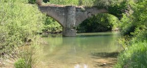
Leaving from Peccioli , we go down the steep via di Greta. In less than a kilometer we get to the gravel bed of Era River characterized by spontaneous vegetation, large and rich variety of birds.
So we continue along the river up to the Molino di Ripabianca . From Le Piagge, where the suggestive vision of tuff cliffs that run along the municipal road Peccioli-Fabbrica follows us on the left, we can make a road variation of up to Ripabianca , to be used in case of flooding of the river.
After approximately four kilometers we start to go up to reach the municipal road with which we reach the charming town of Montecchio and continue, still with the dirt road, in the countryside of the area of Serre, which has varied crops and is natural habitat of various game species. There are two ways of traveling to this area; one is from Costie and the other takes you back to Peccioli through the road of Madonna delle Serre , named after the namesake church in this area, and characterized by a fresh and hospitable little forest, place of pilgrimage the first Sunday of May.
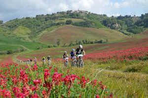
EVENT
Randonnée ARI patent, Randonnée Mountain Bike patent.
INSPIRATION
The event, in line with the directives of ARI, will pursue the following purposes: self-sufficiency, affordability, simplicity, security, contact with nature.
The event was inspired by the slow travelling on nature trails
ORGANIZATION
The ownership of the event is the GSRC Galimberti, with the patronage of the Municipality of Pontedera and the collaboration of G.S. Treggiaia, POL la Perla “Razzi e Mozzi” and Borra Bike with ARI audax randonnée Italy.
The event will adopt the Regulation ARI / MTB.
THE EVENT
DATE
Sunday, August 31st, 2014.
Preliminary checks from 07.00 to 08.00 at the Club Galimberti in Via Galimberti, Pontedera.
Start from 8:00am to 08.10am from GSRC GALIMBERTI.
WHO CAN PARTICIPATE
Cyclists and cycle tourists members with papers in order for the year 2014 ARI, or bodies recognized by CONI UISP; ACSI; CSAIN; ASI; CSI; ENDAS; FITRI, and also free hikers equipped with medical certificate, bike Mountain bike and helmet (mandatory). after filling the release paper ARI.
REGISTRATION
We accept MAX 300 people. The registration fee is € 10.
Entries close automatically when we reach the number of 300 paying cyclists, there is no possibility of pre-registrations.
Registration opens from June 20th, 2014 at the Club Galimberti in Via Galimberti n° 4, Pontedera. – or online via the website www.audaxitalia.it (REGISTRATION)
Registration fee: (10 €) to be paid by bank transfer before you sign up.
Description of payment (“causale”): you have to write “Iscrizione Randonneè della valdera.”
Account name: G.S.R.C Galimberti.
Bank: “Banca di Pisa e Fornacette”.
Bank account details: IBAN – IT37 Z085 6271 1310 0001 0375 939 – SWIFT BIC: BCCFIT33
Registration deadline Sunday August 31st, 7.30am
We recommend the use of RandoCard ARI (cyclist card ARI) to sign up, the preparation of the release of responsibility, which will have to be delivered to the preliminary checks, the validation steps at the start, the control places along path and at the finish.
RACE DOCUMENTS
Road Book route map with street guide (town refreshments and fountains), Paper ARI / MTB / RG as travel validation step in places of control. GPS path track.
THE ROUTE
40 / 70 / 115 km, short, medium and long, as for the ARI / MTB standards.
The “randonnée valdera” will make a great added value to the event, as it allows cyclists to follow paths and roads of GPN and horse trail through hills, woods and streams.
The route is marked as “Randonnée valdera”.
NB: Hikers enrolled arriving at the refreshment / control “LE SERRE” after 13:00pm will not be allowed to continue in the long route.
“We remind that the long path requires a good physical condition.”
Refreshments:
There are 4 food spots on the path next the checkpoints. (Terricciola, Le Serre, Castelfalfi and Legoli) – and a pasta party at the finish.
RECOGNITION
The GSRC Galimberti will distribute to all the cyclists who will get the approval ARI / MTB (40 – 70 – 115 Km) a scroll by the artist Giancarlo Calamai reproducing the logo of the event.
STREETS GUIDE
Roads / dirt roads of Randonneè:
A) PONTEDERA starting 8:00-8:10am from Via Galimberti – towards Ponsacco on the bike path parallel to via roma – underpass in Viale Europa – the street in front of cemeteries – bike path until “La Borra” – path levee Era River.
A) PONSACCO (time 8:15 to 9:15) Trail embankment ERA – via Melegnano – Viale Primo Maggio – via xxv aprile – Via Roma via dei mille – via cesare Battisti – via Era – Roundabout – dirt road to Camugliano.
A) CAPANNOLI (hours 8:45 to 9:45) via Camugliano – dirt road near “Solaia” – via delle pinete – via provinciale 26 – via del Pino – dirt road up to via dei Pontini – via delle case – dirti road via dei monaci – via di badia.
A) TERRICCIOLA (9:15 to 10:30 via di badia – dirt road via taneto – via della cascina – via terricciolese –
Via Bagno “A / R” – (First Food Spot.) dirt road via delle colline.
A). CHIANNI. Dirt road via delle colline – strada provinciale 14 “Miemo” –
A). LAJATICO (10 am – 11.30 am) “Fontanelle” . Dirt road from strada provinciale 14 to strada provinciale 45 – Via Pietro Nenni – unpaved local road via dell’uccelliera “theater of silence” – via Volterra SR 439.
A) PECCIOLI / MONTAIONE (11am – 13:30)
SR 439 – gravel road lake Gattero – municipal road of Montelopio – via di mezzo – Fabbrica – via della chiesa / towards Fabbrica – via delle case nuove – Montecchio – via Aldo Neri – dirt road, via madonna delle serre (2nd Food Spot). – GPN dirt road up to strada della bonifica – via della bonifica – via della bonifica gravel road towards Castelfalfi – dirt road and golf courses. – Castelfalfi (3rd Food Spot) Via SP 26 – via di mezzo / via Poggetta – via di monti – dirt road GPN towards via Libbiano Legoli -.Legoli – (4th Food Spot).
A) PALAIA (12.30 – 15:00) via SP 11 – dirt road up to municipal road Toiano – via Toiano – dirt road collelungo (agliati) until SP36 – Chiecinella – dirt road via della costa towards Marti.
A) MONTOPOLI (13.30 – 16:00)
Via della costa – via fontanelle – via della croce – MARTI – (WATER SPOT) via Mazzana – Varramista – via di ricavo – highway underpass – Castelbosco – dirt road via val di frigoli – via della falce.
A) PONTEDERA (-13 hours – 18) via della falce – municipal road Palaia / La Rotta – via del pietriccio – via di montecastello – cycle path of Braccini lakes – via Enrico de Nicola – cycle lane in Viale Italia – back, through cycle path, in the Era river embankment – arrival via galimberti.
R) FROM TERRICCIOLA (return on short course) – time 10:30 to 11:30 the road of Chianti towards Morrona – Stibbiolo – via dei cipressi – San Pietro Belvedere – via vignoli – via Corsica – provincial road 26 via san rocco – dirt road for Solaia – via Camugliano – Ponsacco – cycle lane on levee Era river – arrival via Galimberti.
R) FROM PECCIOLI (return middle course) (11:00 – 13:30) from madonna delle serre – Municipal road poggio al pino – provincial road 41 – via San Sebastiano – via dei cappuccini – cycle path towards Forcoli – via la bianca – via SP26R, via di santo pietro belvedere – sarzanese valdera – via Baciocchi – Piazza Castello – via san rocco – dirt road under the cemetery towards Camugliano – via Camugliano – via valdera – cycle lane levee Era river – arrival via Galimberti.
A) roads of the long route R) roads of return short and medium course.
Here you can see the video made for the 2014 edition:
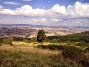
The G.P.N. is a route that winds through the province territory for more than 100 km, it sets up a network connection for all activities of trails, and horse trail that facilitates the visit and the activities in our territories.
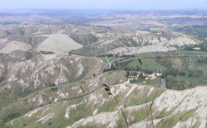
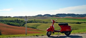
The tour aims to select a portion of precious kilometers of the long and sometimes monotonous SS / SR439 Sarzanese Valdera. The official route would start from Pietrasanta, this is only a summary, which starts the engine in La Sterza and brakes in Massa Marittima. Consider it as a Best Of.
Choosing a starting point, for the sympathy we light the engine in La Sterza: although after a turn on the right, the following kilometers run virtually with straight handlebars. To warm up the tires we have fun in the ups and downs with pit-stop at the village of Lajatico , birthplace of the famous tenor Andrea Bocelli . The relaxing stop is at the Theatre of Silence : a natural amphitheater with a rich musical and cultural program.
start/end: from La Sterza to Massa Marittima lenght: 70km durata: 1 giorno type of road: mix, hills, mountains provinces: Pisa, Grosseto
Utilizzando il sito, accetti l'utilizzo dei cookie da parte nostra. maggiori informazioni
Questo sito utilizza i cookie per fonire la migliore esperienza di navigazione possibile. Continuando a utilizzare questo sito senza modificare le impostazioni dei cookie o clicchi su "Accetta" permetti al loro utilizzo.


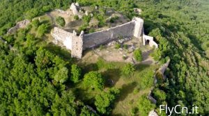
 to San Bartolomeo in the castle.
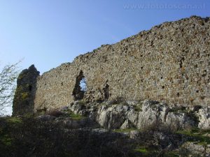 The fort surveilled the territory from the Pianura Pisana and the Verruca at the north to the Sillana Fort at the south The Pietracassia Fort is one of the best examples of military architecture in the area from the late Middle Ages. It dates back to the 17th or the 18th-century, and is one of the first barbaric castles in Tuscany.