Category Archives: trekking @en

Trekking

Trekking Buti-Piavola-Il Sorbo-Quadonica-Buti – Buti

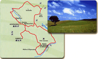
Description of the Trekking:
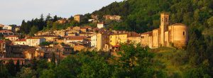
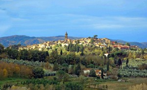
Buti-Piavola

We leave Buti sport field parking and we’ll going up along Monte Aspro slopes, before through an aspalth road (out 2 KM) and after through a path (‘carrareccia’) ,which is within a pine forest, until the crossroad in Loc. l’Aspro, the panoramic view on Buti valley.

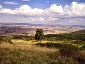
We’ll move on in climb, along the right path until Volpaia Colle, after that we’ll take the left path and we’ll going up Monte Gentivola, walking along Piavola, then we’ll go along Piambello and just out from the wood, we’ll be in front of in a panoramic view,  from where we can admire Valdera.

Piavola-Il Sorbo

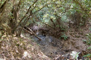
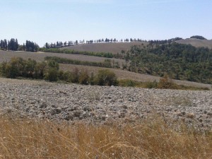
Itinerary continues until meeting Monte Serra country road, from whom we’ll go for 2 km in descent, until to arrive hairpin turn where on the right starts a ‘pista forestale’ and leading in loc. Il Sorbo (435 m s.l.m.) .

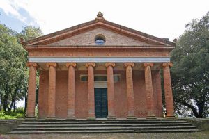
In this suggestive area there are some relays about “Strada Dell’olio Dei Monti Pisani” and different educational trail ,with the possibility of rest area.

From here is possible go along a path that leading to Prato a Giovo, going through Certosa and Montemagno.

Il Sorbo-Quadonica

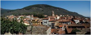
From Il Sorbo we’ll go along ‘pista forestale’ going through Quadonica for about 2 Km, after that, on the left starts a path in descent, it arrives on the road in Mariotto and below goes to Buti (borgo Castel Tonini, sede della Villa Medicea).

Quadonica-Buti

The itinerary goes inside country historical center until to reach the start point, going through Garibaldi square, Martiri della Libertà square and going along Danielli park.


Technical details:

Start point: BUTI SPORT FIELD PARKING

Start share: 127 m s.l.m.

Arrival share: (Loc il Sorbo): 435 m s.l.m.

Maximum climb: 490 m

Distance: circa 16 Km

Mean time of journey: 6 h-7h

Difficulty: medium- easy

Note: For people who says they can walking for long path

Informations:

Address: Piazza I.Danielli, 5 , 56032 Buti (PI)
Telephone: 0587-722511
Fax: 0587-723784
E-Mail: comune.buti.pi@postacert.toscana.it

Website: Buti itineraries


rivalto excursion escursione

Giro di Rivalto Excursion

The excursion is characterized by various types of environments; we pass from a wooded environment, we pass from a typical Tuscan countryside, It’s characterized by hills alternated by watercourses.

During the excursion we can find a typical Tuscan farms, They are sometimes accompanied by the characteristic double to spin of cypresses.

You have to leave the car in the car park of the agritourism “Le Valli”, a cross will guide us to the path.


Attention: Since It is not possible to know the number of participants of the longer path, If the group will be numerous,the group could arrive late, in that case who was waiting the group, he/she can visit Rivalto.

Technical Details

Stroll in the Woods of Rivalto Casciana Terme (Pisa)
Duration: 6/7 h
Itinerary: Agritourism Le Valli – Rivalto – Casciana Terme – poggio alla Farnia – Collemontanino – Agritourism Le Valli
Organized by CAI LIVORNO
Rate non-registered: 10,00 €
Meeting: 9.15 Agritourism Le Valli

It will possible to have lunch at the end of path Agritourism Le Valli -Departure and arrival.
Menu: 18,00 €

Head of excursion: Massimiliano Scavo tel. 347 6045212

Additional information here

La Mofeta di Borboi

The Mofeta of Borboi

The Mofeta of Borboi
The study of the ecosystems of the mofetes – the spillages of carbon  dioxide from volcanic rocks is began some years ago, It has led some scientific results and it has reevaluate the natural environment.

In particular the Mofeta of Borboi in the neighbourhood of Orciatico has led a numerous groups of scientist from all over the world.
It is interesting because it allow to appreciate the realistic effect of carbon dioxide in the future.
The Mofeta is about 1 Km in North of Orciatico, It’s visitable and reachable from a path.

Path of Mofeta of Borboi

Type of path: enviromental, naturalistic, scientific
Lenght: 1,4 Km from the North of Orciatico, 5,5 Km from the South of Lajatico
degree difficulty: easy

Mofeta Orciatico 5

Mofeta Orciatico 1


From Orciatico: If you have left the provincial street to Lajatico, The first 500 meters are accessible on foot, The last path is about 200 meters and it’s accessible on foot.

From Lajatico: Drive to Orciatico, then as above.

Time taken: from the provincial street to Lajatico 15 min. on foot

Era River

Leaving from Peccioli , we go down the steep via di Greta. In less than a kilometer we get to the gravel bed of Era River characterized by spontaneous vegetation, large and rich variety of birds.
So we continue along the river up to the Molino di Ripabianca . From Le Piagge, where the suggestive vision of tuff cliffs that run along the municipal road Peccioli-Fabbrica follows us on the left, we can make a road variation of up to Ripabianca , to be used in case of flooding of the river.

After approximately four kilometers we start to go up to reach the municipal road with which we reach the charming town of Montecchio and continue, still with the dirt road, in the countryside of the area of ​​Serre, which has varied crops and is natural habitat of various game species. There are two ways of traveling to this area; one is from Costie and the other takes you back to Peccioli through the road of Madonna delle Serre , named after the namesake church in this area, and characterized by a fresh and hospitable little forest, place of pilgrimage the first Sunday of May.

Hills in Legoli

The path “la Bianca” that meets the Peccioli prehistoric park with life-size animals.

The path “Anelli di Cedri” (Cedars rings) offers a habitat of flora and fauna of wild beauty.

Horse trail in Lajatico

The G.P.N. is a route that winds through the province territory for more than 100 km, it sets up a network connection for all activities of trails, and horse trail that facilitates the visit and the activities in our territories.

Temple of Minerva – Palaia

The Temple of Minerva Medica is a historic building located on a hill in a small grove of oaks near the village of Montefoscoli.

It was built around 1822 by Andrea Vaccà Berlinghieri, doctor and luminary of the University of Pisa. The intention was to dedicate a monument to his father Francesco, also a doctor, celebrating the profession with a dedication to the medicine goddess Minerva.

Download file: Montefoscoli-partino.gpx
ripassaia

Ripassaia Mill Route – Molino della Ripassaia

Leaving from the suburb of “Fabbrica”, after few hundred meters we leave the paved road and get into a beautiful landscape, multicolored during springtime by the many different crops: oat, lucerne etc..

On the clay hills, we descend to the plain “Ripassaia”, which was created by the “Era” river, and we walk along for around 2 kilometers; in summer is full of brooms and wheat fields. At the farm “Tonaca” we go uphill again, and we find the fishy “Gattero” lake on the right.

From the hills of “Diacceroni”, we go up again to the resort “Montecuccheri”, shortening the path, or we can decide to continue towards “Poggio Rosso”, walking through stretches of dense vegetation, until we find the road “La Bonifica”. After about 3 kilometers, we take the road to “Montelopio-Fabbrica”, ending up the route here.

Percorso del Molino di Ripassaia

Ripassaia Mill Route